MOAB, UTAH

The Maze District

Canyonlands’ Most Remote District
Most people who visit Canyonlands never make it here. The Maze sits in the southwestern corner of the park, accessible only by 46 miles of unpaved road from the nearest highway, with no services, no cell coverage, and no casual entry point. Backcountry permits are required for overnight stays. A high-clearance 4WD vehicle is required for the entire trip. The road washes out in the rain. That is the point.
For the people who come anyway, The Maze delivers a kind of solitude that is genuinely rare in the American West. The canyon systems are deep, the rock formations are surreal, and the sense of being in one of the most isolated places in the lower 48 is not a marketing claim; it is accurate. This guide covers the logistics honestly so you can decide whether The Maze is the right trip for you, and what the Moab Adventure Center offers if you want a guided Canyonlands experience without the backcountry commitment.
One of the most remote places in the lower 48. No tours. No services. No casual visitors.
Fewer than a handful of people are typically in The Maze on any given spring weekend. Where Island in the Sky draws hundreds of visitors, The Maze draws a fraction of that, not because it is less spectacular, but because getting here requires a vehicle, a permit, and the skills to navigate without a trail. That ratio is the entire point of visiting
Canyonlands National Park Quick Links
What is the Maze District?
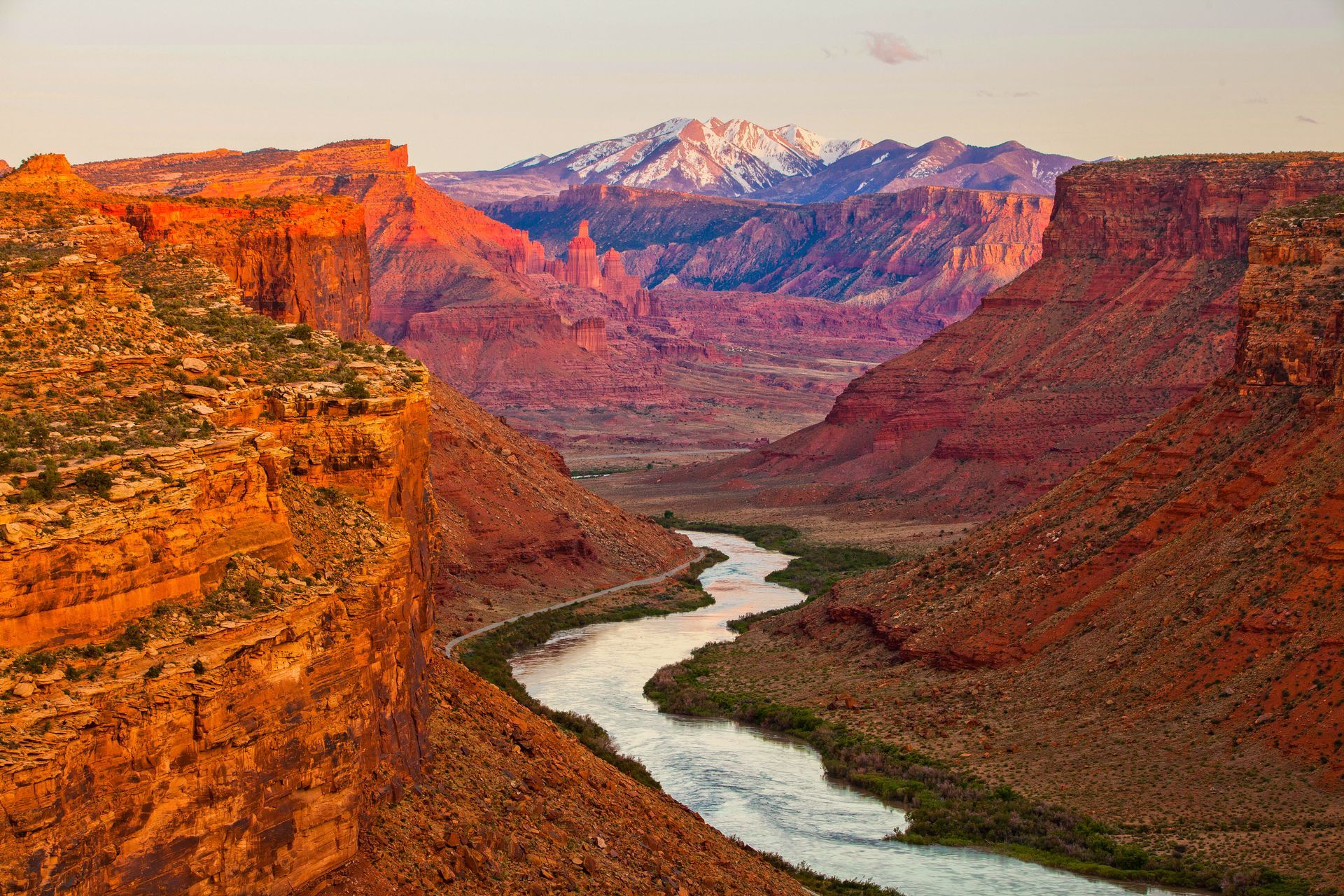
The Maze occupies the southwestern district of Canyonlands National Park, west of the Colorado River and south of the Green River. The district borders the Rivers district to the east and shares the park’s southern boundary with Glen Canyon National Recreation Area.
There is no direct paved road from Moab to The Maze. The standard approach runs via UT-24 west from I-70, then south on a BLM dirt road to Hans Flat Ranger Station, approximately 46 miles of unpaved travel from the pavement. From Moab, the total drive is roughly 130 miles and takes three to four hours, depending on road conditions. An alternative approach enters from the west via the Hite Marina area near Lake Powell, but this route is similarly remote.
The name comes from the canyon system itself. Drainage branches repeatedly from every main channel, dead-ending without warning and offering no visible landmarks to orient by. First-time visitors consistently describe it the same way: every canyon looks like the one they just came from. Navigation without a topographic map and compass is not difficult here; it is dangerous.
Getting There from Moab
The Maze is approximately 130 miles from Moab. The drive takes three to four hours each direction, depending on road conditions. There is no paved access to the district.
Driving Directions from Moab
From downtown Moab, head north on US-191 to I-70 west. Follow I-70 west to the junction with UT-24 and turn south. From UT-24, turn onto the BLM dirt road that leads approximately 46 miles to the Hans Flat Ranger Station. The road is unpaved clay and becomes impassable when wet. Do not attempt entry after rain or if rain is in the forecast.
Entrance Fees and Permits
- Park entrance fee: $35 per vehicle, valid for 7 consecutive days (America the Beautiful pass accepted).
- Backcountry permit: Required for all overnight camping in The Maze. Reserve in advance at recreation.gov. Spring dates fill months in advance.
- Day-use: Day visits to certain trailheads, including the Maze Overlook, do not currently require a permit. Given the drive time involved, most visitors stay overnight.
Trails and Routes in The Maze
The Maze has one formally defined trail. All other travel in the district is cross-country navigation using a topographic map, compass, and the experience to use them reliably. Route-finding errors here can have serious consequences — rescue response times are measured in hours, not minutes.
All distances listed are round-trip for defined routes. Cross-country routes vary by line taken. A USGS 1:24,000-scale topographic map and compass are required for all travel beyond the Maze Overlook trailhead. GPS devices are useful but should not be the primary navigation tool
| TRAIL | DISTANCE | DIFFICULTY | NOTES |
|---|---|---|---|
| Maze Overlook Trail | 3.9 mi RT | Strenuous | Rope-assisted section into the canyon; direct view of the branching canyon system; sparse cairns |
| Land of Standing Rocks | Varies | Strenuous | Route-finding required; no marked trail; 4WD access to interior trailhead required |
| Chocolate Drops | Varies | Strenuous | Overland travel from Maze Overlook area; used as navigation landmark; no formal trail |
| Doll House Area | Varies | Strenuous | Visual centerpiece of the district; requires full interior 4WD approach; no marked trail |
Best Time to Visit The Maze District
Spring (April through May) Best conditions for hiking and camping. Temperatures are moderate, water sources are more reliable, and wildflowers appear in the canyon terrain. Busiest permit window — apply months in advance.
Summer (June through August) Temperatures regularly exceed 100°F. Canyon terrain amplifies heat with no shade. Possible for experienced desert travelers with exceptional hydration discipline, but not recommended for most visitors.
Fall (September to October) is the second-best window. Cooler temperatures, excellent canyon light, and slightly less permit competition than spring. Monsoon activity can linger into early September.
Winter (November through March) Cold, with potential snow and ice on the access road. Some years the road closes entirely. Solitude is absolute for those who make it in. Check road status with Hans Flat before a winter trip.

Frequently Asked Questions About Island in the Sky
How hard is The Maze to get to?
Hans Flat Ranger Station is the main entry point and sits about 46 miles from UT-24 on unpaved clay road. A high-clearance 4WD vehicle is required. The road becomes impassable when wet. From Moab, plan on three to four hours of driving each direction.
Do you need a permit to visit The Maze?
Overnight backcountry camping requires a permit reserved in advance at recreation.gov. Spring dates fill months out. Day visits to certain trailheads, including the Maze Overlook, do not currently require a permit — but given the drive time, most visitors stay overnight.
What trails are in The Maze district?
The Maze Overlook Trail is the only formally defined route: 3.9 miles round-trip, rated strenuous, with a rope-assisted section descending into the canyon. All other travel in the district is cross-country navigation using a topographic map. Route-finding errors in this terrain carry real consequences.
How is The Maze different from Island in the Sky?
Island in the Sky is paved-road accessible, 32 miles from Moab, and has maintained overlook trails suitable for most visitors. The Maze requires a 4WD vehicle, a backcountry permit, a three-to-four-hour drive on unpaved roads, and serious navigation skills. Island in the Sky is a half-day trip. The Maze is a multi-day expedition.
Can you take a guided tour to The Maze?
No guided tours currently operate into The Maze. The permit system, access constraints, and wilderness demands make it unsuitable for group operations. If you want a guided Canyonlands experience, MAC offers Cataract Canyon river trips through the adjacent Rivers district and air tours that fly directly over The Maze. Both depart from Moab.
What is the best time of year to visit The Maze?
Spring (April to May) and fall (September to October) are the best windows. Temperatures are moderate, permit competition is highest in spring, and conditions are most reliable. Summer heat in the canyon terrain regularly exceeds 100°F. Winter is possible for experienced desert travelers but the access road can close without warning.
What is The Maze known for?
The Maze is known for being the most remote and technically demanding district in Canyonlands. It is named for the labyrinthine canyon system that makes navigation without a topographic map genuinely dangerous. Most visitors to Canyonlands never reach it — and that isolation is exactly what the people who do come are looking for.
Is The Maze worth visiting?
If you have the vehicle, the permit, the navigation skills, and the time for a multi-day trip, yes. Few places in the lower 48 offer this combination of geological spectacle and genuine isolation. If you are looking for a day trip or a first Canyonlands experience, Island in the Sky is the right starting point.
Not finding what you're looking for?
Rivers District
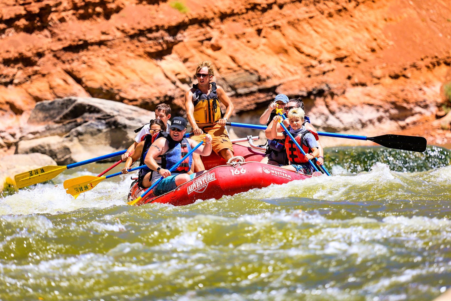
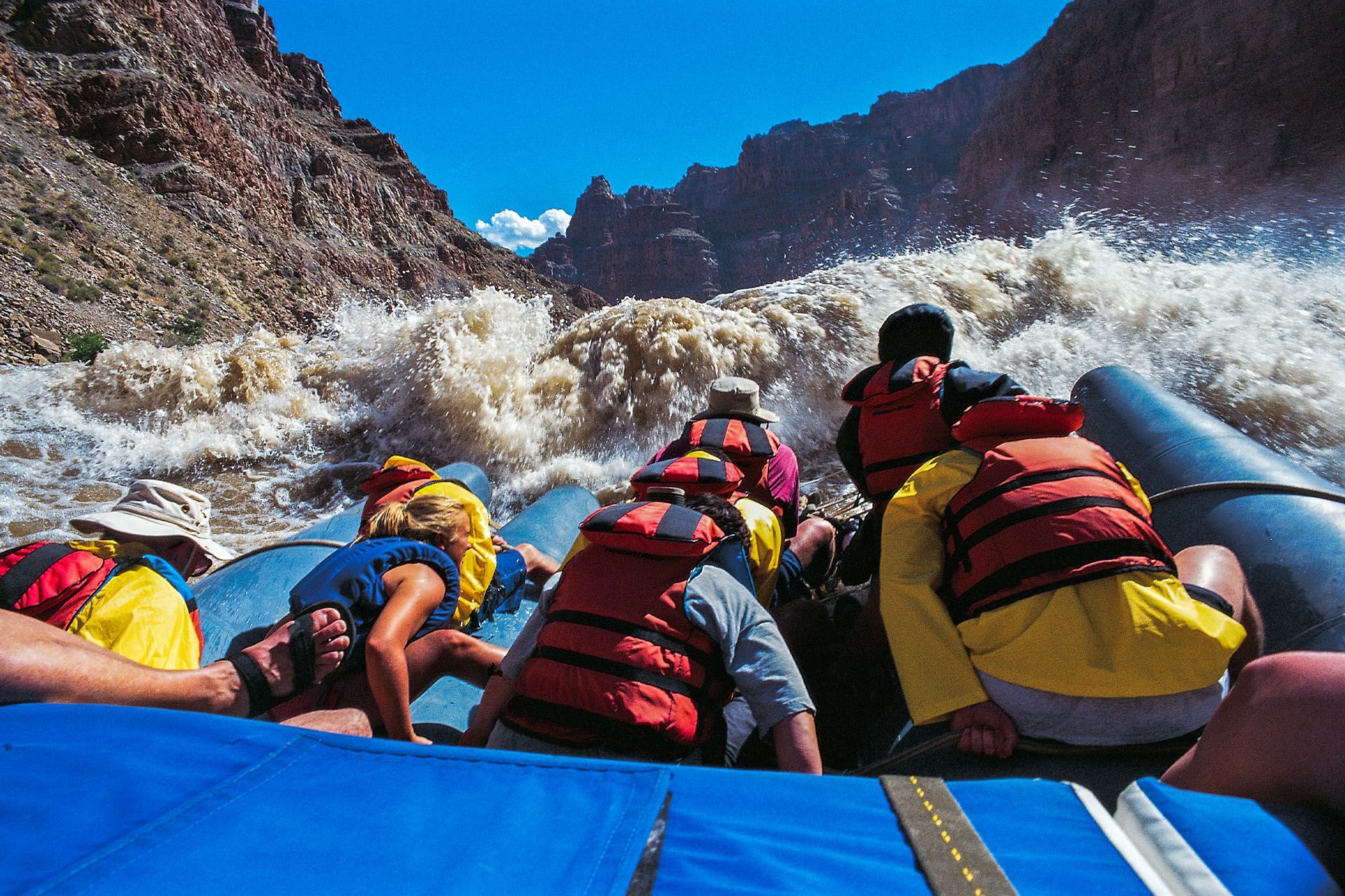
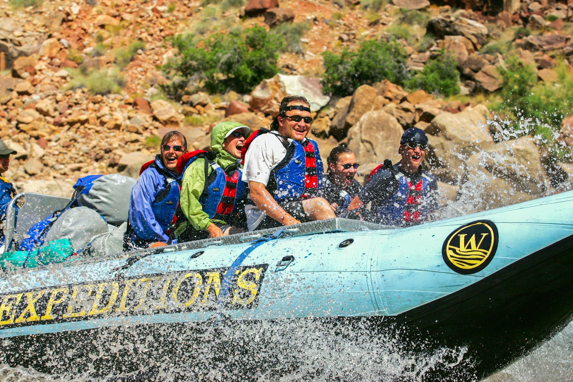
he canyon corridor at the heart of Canyonlands, where the Colorado and Green Rivers meet at The Confluence and drop into the whitewater of Cataract Canyon below. No roads reach this district. You arrive by raft or by air. Most park visitors stand at the rim and look down. Moab Adventure Center's guests float through the bottom, past 14 miles of named rapids, the Big Drop sequence, and the canyon walls that frame the park from below. The deepest, quietest, and most dramatic section of Canyonlands.
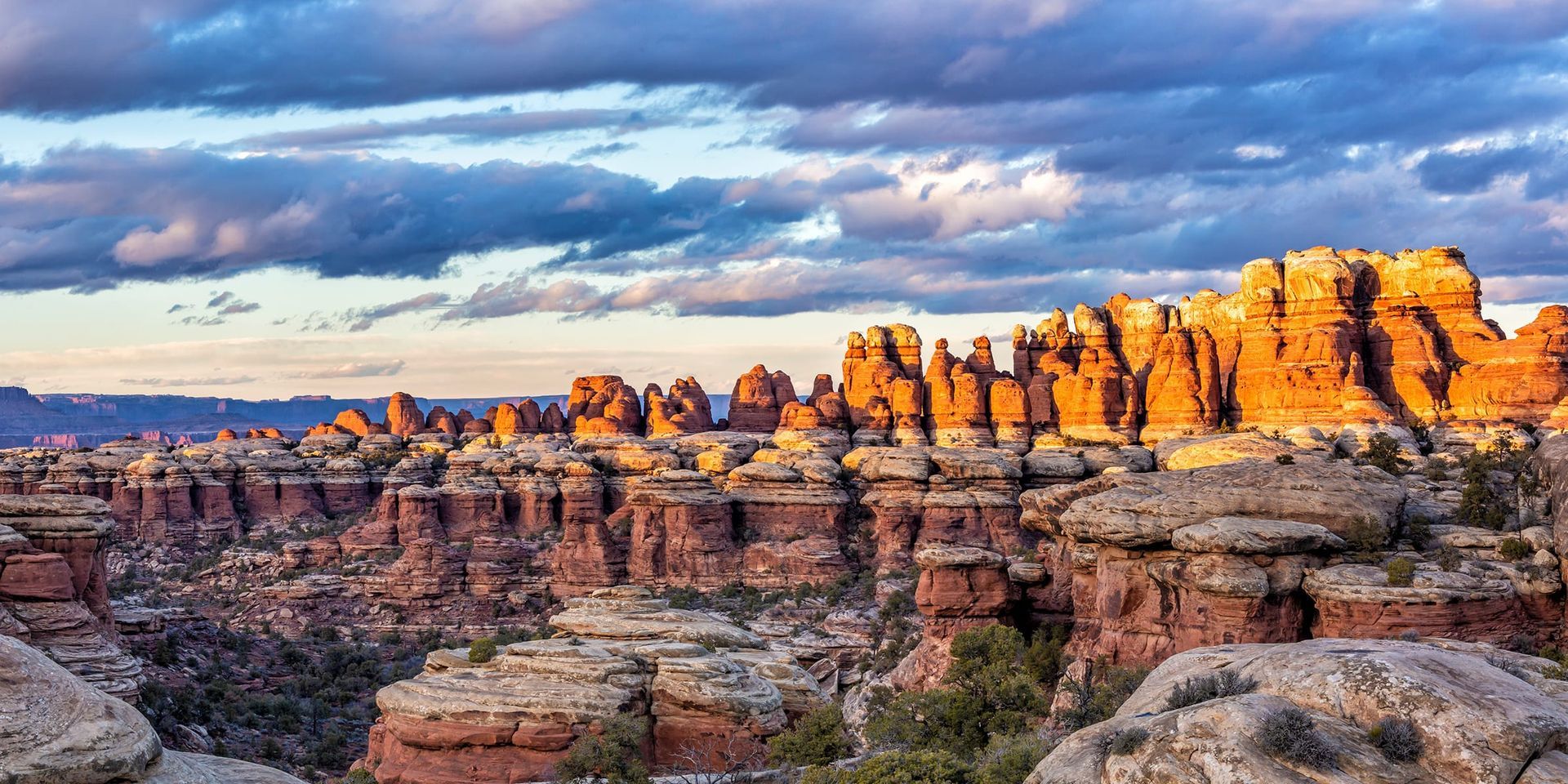
Needles District
Cedar Mesa Sandstone spires rise 400 feet from the canyon floor in banded red and white columns, striped by 300 million years of mineral deposit. The Needles is built around its trail system, with slot canyons that close to 18 inches across, open meadows ringed by rock formations, and one of the most distinctive backcountry experiences in Utah. 75 miles from Moab and worth every mile if you came here to hike. Day-use permits are required for most trails, including Chesler Park and the Joint Trail.
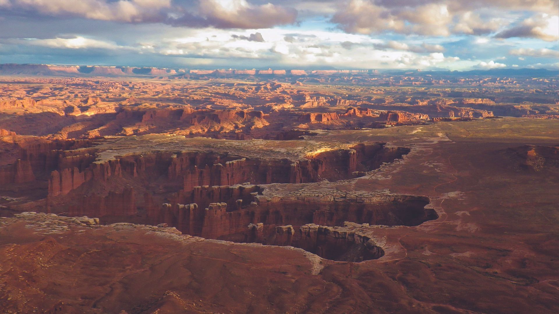
Island in the Sky District
The most accessible district in Canyonlands, 32 miles from Moab on a paved road. Stand at Grand View Point and the ground drops a thousand feet in every direction, with views reaching 100 miles on a clear day. Mesa Arch frames the La Sal Mountains at sunrise, glowing orange when canyon-reflected light hits the underside. Upheaval Dome holds a 3-mile-wide crater whose origin still puzzles geologists. If you only have one day in Canyonlands, this is the district that delivers the iconic views with the least effort.
Experience Canyonlands Without the Logistics
The Moab Adventure Center does not offer guided tours into The Maze. The permit requirements, access constraints, and technical wilderness demands make it unsuitable for group tour operations.
If you want a guided Canyonlands experience that puts you in the same canyon ecosystem, Moab Adventure Center runs two options that do exactly that.
The Colorado River flows through the Rivers district, directly adjacent to The Maze, through the deepest canyon terrain in the park. Cataract Canyon trips launch from Moab and travel through this canyon, past The Confluence, and through Class III to V rapids below. The canyon walls you float between are part of the same formation system that defines The Maze to the west — a different angle on the same wilderness, from the river floor instead of the canyon rim.
For an aerial view of The Maze itself,
Moab Adventure Center's scenic air tours provide the only way most visitors will ever see the full geometry of the district.
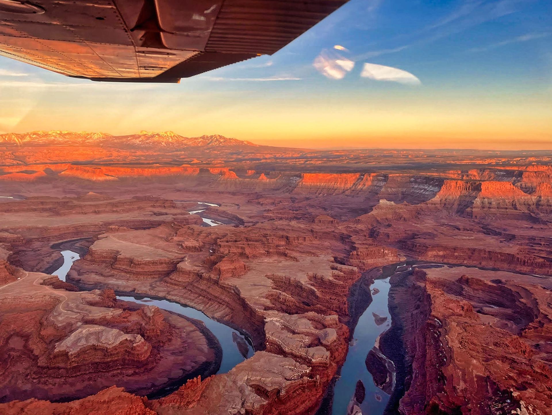
Canyon country like you’ve never seen it: Soar over remote arches, deep canyons, and the vast beauty of the Needles District. All at the perfect time of day.
- Duration: ~1 hour
- Departures: 1 hour before sunset (changes seasonally)
- Season: Year round
ADULTS 13+
$374
YOUTH 3-12
$374
Journey 100 miles through remote red rock canyons with roaring whitewater & star-filled nights on this all-inclusive expedition from Moab to Lake Powell.
- Duration: 4 Days
- Departures: Weekly
- Season: Jun -Aug
ADULTS 16+
$2,050
YOUTH 10-15
$1,750
An epic, fast-paced, 2-day journey through Canyonlands National Park with roaring rapids, deep wilderness & star-filled nights on the Colorado River.
- Duration: 2 Days
- Departures: M, W, F
- Season: May - Jul
ADULTS 16+
$1,150
YOUTH 10-15
$1,150
GET THE FREE MOAB INSIDER'S GUIDE!
Join our Moab Insider Email Series
and get our free Moab Insider's Guide
. It's your shortcut to where to stay, can't-miss adventures, recommended restaurants, hidden gems, and how to make the most of Arches & Canyonlands. Real local tips, easy itineraries, and expert advice so you can plan less and experience more
.
BECOME A MOAB INSIDER
With our Moab Insider's Gide and email series, you'll get local tips on the best dishes at restaurants, hidden adventures that most people miss, tips on when to visit, and a few more secrets on the side. Get all the essentials for the perfect Moab experience.
Free. Instant download. Unsubscribe anytime.
⭐️⭐️⭐️⭐️⭐️ 7,000+ 5-Star Reviews | 22-Time Best of State Winner